Enables locate and engineering teams to gather information about their underground world and integrate it with other business systems such as their Geographic Information System and / or Enterprise Asset Management System.
Capture your locate information accurately, the first time
Utility Mapper
The 2019 DIRT report estimated that there was in excess of $30 Billion dollars’ worth of damages in the United States and those numbers are trending upwards. Canada’s utility damage costs were more than $660 million with approximately 4000 to 5000 reported damages in Ontario alone.
Accurate record keeping and high precision data collection of assets when they go in the ground is critical. After burial, capturing and storing the required locate information helps tremendously in maintaining an accurate record of all assets and of the activities in the area that concern them.
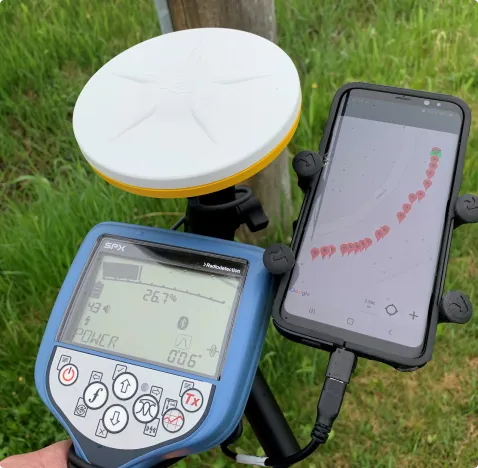
Utility Mapper integrates directly with both high accuracy GNSS (GPS) positioning systems such as those provided by Trimble and Eos, as well as high performance utility locate sets including those built by Radiodetection, Vivax-Metrotech and Rycom.
One click locate-and-map technology saves time and money. Capture ALL locate information and spatial information at the same time. Choose to complete your locate either in field or in the office with Data Engine’s online Sketch functionality.


Product Specification Details
- GNSS Support
- Trimble Catalyst
- Trimble R Series
- Trimble Spectra Precision
- Eos GNSS
- Radiodetection RD8200SG
- Vivax-Metrotech RTK Pro
- Geometry Collection
- Point
- Line (with per vertex details)
- Line extend functions
- Polygon (with per vertex details)
- Point delete / Line delete
- Attributes (unlimited number)
- All GNSS metadata (accuracy, satellites, etc.)
- User information (name, email)
- Date / Time information logged
- Text attributes
- Dropdowns (with “Other” opens a text box to capture a non-defined item)
- Radio Button choices
- Photo capture
- Collection methods
- Individual Point (i.e. valve)
- Timed multi point or line – user tracking, generates data on a timed interval
- User chosen multi-point – user decides when to collect the next point (i.e. hydro line with discrete locations)
- Sensor driven – Utility Locator, when user taps “Log position” Utility Mapper collects data from the Locate set and logs the GPS point simultaneously
- Integrations
- Radiodetection RD8100, RD8200 & RD8200SG
- Vivax Metrotech vLoc2, vLoc3, vLoc3 RTK Pro (all with Bluetooth chip)
- Rycom Pathfinder
- Navigate to point (Stakeout functionality)
- Operating System Support
- Android v4 and above
- Android v4 and above
- Map making
- Default map with underling maps / aerial imagery
- Turn points on / off
- Ability to draw offsets / building lines and other items (configurable)
- Ability to support custom symbols (i.e. valve symbols, line styles, etc.)
- Ability to define map output (all in one, per utility, etc.)
- Data Export
- CSV
- KML
- Shapefile
- ArcGIS Online / ArcGIS Portal – support for Esri Dashboards, Esri GeoEvent Server, etc.
- Standard DXF Template
- AutoCAD DXF can be configured to meet your Block and Line standards
- Data Import
- DXF
- KML
- ArcGIS Online / ArcGIS Portal
- Fully web-based backend
- Secure environment
- Per client databases (no mixing / matching of data in one giant database)
- Database can be geolocated where Microsoft Azure has a data center (by default databases are stored in Canada)
- System is fully secured and managed in Microsoft Azure datacenters
- Database hybrid support – if the database needs to be housed internally, this can be supported
- All data owned by client – TerraFlow does not retain ownership of data collected, it’s yours, we just help store and manage it
- Support
- Full support of the application
- Development upgrades are frequent
- Very receptive to client feedback and improvement requests